Fabulous vistas and amazing artifacts await eager hikers along the central section of Hadrian’s Wall Path. Listen as Emily and Cam chat about them all in this installment of their series on the Wall. Get ready for Roman Army re-enactors, the world’s oldest surviving document written by a woman, and the tree that stole the show from Kevin Costner and Morgan Freeman—but watch out for the cheesecake!
Visit our homepage to subscribe, to find us on social media, and to contact us by email:
----------
00:11 - Introduction
01:19 - Dialects: Cumbrian and Geordie
05:30 - Sewingshields Crag
- 06:38 - Views of the North Ditch
- 07:40 - Preserved lengths of Wall along the Great Whin Sill
- 09:31 - The summit of Sewingshields, gale warnings, and Joe the Dog
13:02 - Housesteads Roman Fort
- 13:39 - History, layout, and garrison of Vercovicium
- 14:51 - Exploring Housesteads
- 16:52 - The Ermine Street Guard: a modern Roman Legion
19:51 - Hotbank and Highshields
22:51 - Sycamore Gap
- 23:27 - The Sycamore that starred in Robin Hood: Prince of Thieves
- 25:07 - The senseless destruction of the tree (and some original Roman masonry)
26:33 - Twice Brewed and Vindolanda
- 26:44 - The Twice Brewed Inn: beds and beer!
- 27:33 - Vindolanda and its history: the forts of the Stanegate
- 29:08 - Exploring Vindolanda (and practicing your Latin!)
- 29:57 - Vindolanda's anoxic soil and archaeological treasures
- 31:17 - The Vindolanda Tablets: Sulpicia Lepidina receives a birthday party invitation, and Maculus wants beer!
35:31 - Peel Crags to Walltown Crags
- 36:51 - The Peel Crags and Castle Nick (or Milecastle 39)
- 38:10 - The literal high point of the trail: Windshields Crag
- 38:52 - Views of the Vallum
- 40:16 - An encounter with a real-life snooty professor
- 41:52 - The Carvoran Roman Army Museum, and some cool archaeology
45:26 - The Irthing River Valley
- 46:18 - Thirwall Castle and plundered wallstone
- 47:01 - The Roman bridge at Willowford
- 47:41 - Milecastle 49 and the junction of the turf and stone Walls
- 48:24 - The walk to Birdoswald: Centurion Stones and Apotropaic Stones
49:20 - Birdoswald Roman Fort
- 49:36 - The history of Banna and its residents
- 50:19 - Exploring Birdoswald and points nearby
- 51:26 - Cocidius: a “Romanized” Celtic war god
- 52:41 - Birdoswald's afterlife: warbands, reivers and Henry Norman
- 55:19 - A misadventure with English cheesecake
56:05 - Wrap-up
[00:00:11] Hello, welcome to Have Toga, Will Travel, a podcast exploring the Mediterranean world, ancient and modern, through the eyes of two former classics professors. I'm Emily. I'm Cam. And we're your hosts. So we're back for another installment in our discussion of Hadrian's Wall and the hiking trail that runs along the old course of the wall. So last time we talked about our experiences hiking the wall, starting at Wall's End near Newcastle and going up to Karabroof right before the wall.
[00:00:41] Before you hit the Crags. What we're going to do today is carry the story over the central chunk of Hadrian's Wall Path. It's a chunk that runs for 15 plus miles between Karabroof on the east and the river Earthing in the west. So basically we're doing the chunk with the Crags today. So those of you who are like elevation nerds, get your pens ready. It's not just elevation. There's also a lot of fun stuff to see that we're going to talk about too, right? You know, museums, forts, spectacular vistas,
[00:01:11] all of that good stuff. Yes, this is the best views of the wall path. For sure. Yeah. So this is going to be a great episode. So stay tuned. Now, as Emily mentioned, we ended last episode by talking about the Mithraeum at the old Roman fort of Brokulitia at modern Karabroof.
[00:01:28] And because we've brought up Karabroof, this seems like an appropriate moment to take a short digression on dialect, the versions of English that are spoken by people living in Hadrian's Wall country. The reason this is an appropriate spot is because if you look at a map, you will not see a place called Karabroof. Instead, you will see a place that looks like it ought to be pronounced Karaburg or Karabura or something like that, maybe?
[00:01:54] C-A-R-R-A-W-B-U-R-G-H. Karabroof. Yes. So the question, why on earth is that B-U-R-G-H pronounced bruff? Well, so first of all, it's important to note what a dialect is. So a dialect is not just accent, right? Accent is pronunciation. And a dialect incorporates things like grammar and vocabulary and things like that. So it's a much broader category than accent.
[00:02:21] And when you're hiking Hadrian's Wall, there are two main local dialects that you might encounter. So one is the Cumbrian dialect, which is considered to be in decline. So there are fewer people who speak like this. But the Cumbrian dialect is a northern English dialect with lots of vocabulary in common with Scots. And Scots is basically a sister of modern English. They both descend from Middle English.
[00:02:46] And then Cumbrian also has influence of Cumbric, which is a Celtic language that had been spoken in the area. And particularly, it survives on numbers used for counting sheep. That's a really weird way to survive, but okay. Hey. And so the pronunciation of Karabroth is actually something distinct to the Cumbrian dialect. Now, if you know someplace, say, Edinburgh in Scotland, right, you're going to hear it pronounced Edinburgh, even though that B-U-R-G-H is spelled the same way.
[00:03:15] And that's because both of those suffixes, or the second half of the word in both cases, are coming from an Old English word that means like fortified settlement. It was something like buch. So what's happened in the Cumbrian dialect, for some reason, okay, linguistic nerds, just this is for you. There's been a metathesis, meaning the R and that U vowel have switched places in the pronunciation. And this is something that happens a lot in English just across the board, this R metathesis.
[00:03:44] And at the same time, the G-H consonant cluster at the end of the word that had been something like a German C-H in Old English goes in a lot of different directions, including towards an F in some words. So like the word cough shows that same sound shift. So with caribruf, and generally with that bruf, B-U-R-G-H suffix in the Cumbrian dialect, you have both the F sound coming in at the end, and you have the R and the vowel switching places.
[00:04:14] And so that's what's happening there. So that's the one dialect is Cumbrian. Right. The other dialect is closely related to Cumbrian, and it's the Jory dialect. This is basically Newcastle English. And it is a dialect which, like Cumbrian, derives ultimately from Northumbrian. Northumbrian was a version of Old English, which has preserved a lot more features of Old English itself than other dialects have.
[00:04:39] Showed a lot of influence from Old Norse, and as Emily mentioned, is closely related to Scots. And among other things, Geordi has a reputation for being one of the dialects in the UK that's most difficult to understand. Even for other people from the UK. Yeah. I had a really fun time calling, twice-brit-in actually. Yes. To make a reservation on our first trip.
[00:05:02] Because, you know, the phone was answered by a very pleasant, friendly young woman who said something that I completely failed to understand. But which I'm pretty sure from context was, hello? But you actually don't know whether that was a Geordi accent or a Cumbrian accent. That's true. I mean, you know, some accent that I couldn't quite decipher. I managed to muddle my way through that conversation, even though I probably only understood less than half of what she said. But we did get a room at the end, so I succeeded somehow. We had a place to stay.
[00:05:32] So, anyhow, that's our little digression on dialect. And you're going to hear this brough word come up in some other place names as we go through. But as you move west from Karabruf, hikers are going to encounter the Great Wynn Sill, which is basically a big layer of volcanic rock that has shoved its way in between the layers of limestone and sandstone and created this line of sharp cliffs and hills that we conventionally call the crags.
[00:05:58] And those crags are really a roller coaster of ups and downs, which consist of three major peaks and lots of little ones. Coming from the east, the first crag you encounter really is a big one, one of the three biggest, as a matter of fact. And it's the crag called Sewing Shields, which tops out at just over 325 meters. That's 1,065 feet. Now, happily, at Karabruf, you're already at about 250 meters because of the climb up of the North Tyme River Valley.
[00:06:28] So you don't have to go all the way up to 325 meters from nothing. But still, brace yourself for a bit of a climb here. It looks quite dramatic when you see it. It really does. And the path here from Karabruf runs along the north side of Military Road. And it does actually give you a really good view of the north ditch as you're approaching the crags. Right. Hopefully you remember back to our overview of Hadrian's Wall. The north ditch ran alongside the wall from end to end, basically,
[00:06:54] to create a bit of an obstacle for people approaching the wall from the north. And in places, it was pretty deep. And you get a good view of it here. More exciting, though, is the fact that as you climb up Sewing Shields, you are taking your first steps on a stretch of about 15 miles that's going to take you across the Great Wind Sill and show you a bunch of really, really interesting and well-preserved sections of the wall. And this is partly because Military Road, when it was built, it was built over top of the wall.
[00:07:24] However, when it hit the crags, it had to skirt around the crags rather than going up and over them as the wall itself does. So the wall survives here because it wasn't destroyed by the road builders because that Military Road was built in the flatter area south of the crags. So that means you will see a lot of surviving traces of the wall. Now, strictly speaking, a lot of what you're going to see is not original.
[00:07:49] Rather, what's happened is that the remaining masonry that wasn't plundered by the 19th or 20th century has been consolidated by various people or groups over the past century or two, especially by English heritage. And this is tend to be called the consolidated wall. Now, the original Roman masonry was mostly dry in that it didn't use mortar. But English heritage, in the work that they've done to reconstitute the surviving blocks that haven't been plundered,
[00:08:17] have used mortar and other bonding agents to create a more durable living monument. And as you ascend up sewing shields, you can see really good examples of their work, including a couple turrets. Turrets, as I'm sure you all remember from earlier episodes in this series, were, along with mile castles, the major features of the wall from end to end. Mile castles punctuated the wall every Roman mile. They housed garrisons of about 32 people.
[00:08:46] And between each of the mile castles, there were a couple of turrets spaced at intervals of about a third of a Roman mile each. And those turrets would usually have a squad of like eight to ten people who just kept an eye on the surrounding countryside. What makes the stretch at sewing shields really exciting is that while you are going to see a bunch of consolidated wall, you will encounter a couple of very small stretches along the path where original Roman dry masonry is still basically in place,
[00:09:14] including a stretch near what we usually call Mile Castle 35, which you'll find maybe about halfway up the sewing shields crag itself. It doesn't look like much. You're only going to see a few foundations, but it's still really, really exciting to see genuine Roman stonework still in situ. At the summit of sewing shields crag, you get some fairly dramatic views in all directions. And if the weather is clear, it really is just phenomenal views you can see so far. And if you look to the west,
[00:09:44] you can actually make out the line of crags that the wall is going to go over. You can even see the wall sort of going up and down them. And then the occasional punctuation of that vista by lakes or what get called in the area lofts. There's that dialect popping up again. L-O-U-G-H loft. Yes. Clearly related to lock. Yes. Right. But yeah, pronounced a little bit differently here. Anyway, the views from the top are really stunning.
[00:10:10] But I think the reason we both remember sewing shields so vividly is because we had a couple of, I guess, fun, quotation marks, experiences here. Fun experiences, yeah. One was more fun than the other. They were memorable. They were memorable experiences. So on our first trip, we climbed sewing shields on a nasty, nasty day when the winds were blowing steadily at about 30 miles an hour and were gusting at times up to 60 miles an hour. There'd been a gale force wind warning for the east coast of the UK that day.
[00:10:40] Yeah, it was not a nice day. And that made sewing shields a little bit challenging. I feel like Jim Corbett, of course, prediction came true the very next day. Yeah, it was not nice to have that wind in our face. that was the same day. Jim Corbett's prediction came true later that day. Yes, that's right. Yeah. He had warned us about this possibility earlier that very day. And he was right. Mm-hmm. And I think what I remember most vividly is getting up to the top of sewing shields, Craig, where there is an ordinance survey marker, I don't know,
[00:11:09] about four feet tall or something like that. Yeah. And a gust of wind slammed you up against it, basically, and kept you trapped there. Well, I leaned over to read the top of it, and then the wind was blowing so hard with the pack on, I wasn't sure how I could push myself off and keep my balance, and I got stuck. Yeah, those packs did act like great big sails. They did. Not my finest moment on that trip. No. We had a better memory on the second trip, which is we were coming up the other side of sewing shields,
[00:11:37] and we ran into some other hikers coming the opposite direction who had a dog with them. And the dog was very friendly, and I was petting it, and they're like, yeah, he's not our dog. Feel free to like take him, let him go with you. The dog walked with us for a little bit, and then more hikers came the other way, and he went with them. It was a border collie, and we started joking that this was a local farm dog that was just bored and had wandered off, and I started making up all these stories about Joe the dog. Whatever, this is how we were passing the time. And then, I don't know what,
[00:12:07] five, ten minutes after we had parted ways with Joe the border collie, a farmer came up. We got up to the top of sewing shields again, and we were standing there just sort of, you know, admiring the view, and farmer drove up on his quad. With two other collie dogs. Yeah, and he sort of stood there gazing out at the same view we were looking at for, I don't know, 30 seconds, and then randomly he turned to us and said something, which was sort of indecipherable, but I'm pretty sure it was, have you seen a collie dog roaming around up here? And we were like, yeah,
[00:12:37] he's been fucking with hikers down that way. Yeah. And so, you know, he went off with the dogs, and, you know, to look for Joe, and, oh my gosh, that's just, the stories about Joe just got better after that, because I was like, I was totally right. He's totally like the screw up dog on the farm, who keeps wandering away, and like. Yeah, herding sheep, herding hikers, what's the difference? Oh my god, it was, it was, oh, so much fun. Anyway. Anyway, from the top of Sewing Shields, if you keep carrying on west,
[00:13:06] a walk of about a mile and a half, that's two and a half kilometers, will bring you generally downhill, with a couple of sharp upward bumps, to a Roman fort. Specifically, the Roman fort Vercovicium, better known these days, as Haustetts. This is an exciting moment, it means you're somewhere between Roman mile 36 and 37, along the old course of the wall, which, as I'm sure you remember, stretched for 80 miles. And in terms of trail distance, you've made it about 47 modern miles, 75 kilometers,
[00:13:36] which puts you just a little bit past the halfway point. So this fort was built originally in the 120s or 130s, as part of the wall construction, and then was later renovated, when the Antonine Wall to the north was abandoned, and they re-garrisoned Hadrian's wall. However, unlike the fort at Chester's, that we talked about in the last episode, this fort did not straddle the wall, it fully projected to the south of the wall, and so all of the gates on the south, east, and west,
[00:14:05] all projected into friendly territory, so to speak. Like most forts, it did have a full circuit wall, and that circuit wall enclosed a pretty big area of about 2.2 hectares, that's five and a half acres, and more than 800 soldiers lived here for much of the fort's life. Those soldiers were auxilia infantrymen. They belonged, as far as we can tell, to a unit called the Cohorts Prima Tungrorum, the first Tungrian cohort,
[00:14:32] which consisted of soldiers originally recruited from what is now Belgium. This fort is the best preserved fort along the wall. You can wander the entire circuit wall, you can check out the foundations and lower courses of the fort's gatehouse, and towers, and you can also explore the foundations of several buildings in the fort's interior. Now, most of the barracks buildings aren't really visible anymore. The foundations are there, and they've been explored archaeologically, but you can only see the lower courses of a couple of those. There are, however,
[00:15:00] exposed remains of a couple of other really cool buildings. There's the commander's house, there's the headquarters building and hospital, and then, of course, there are some granaries with their characteristic raised floors. But, most famously, what you also get to see tucked away sort of out of the way in the southeast corner of the fort are the communal latrines. And here you can clearly see where the, quote-unquote, seats of ease once sat up close and personal. Yeah, you were elbowing each other, basically, when that thing was full. Yeah.
[00:15:31] And you can also see the water channels underneath that would have flushed the waste out of the fort itself. Yeah, some interesting gestures toward basic sanitation there, right? Yeah. And keep the fort itself less smelly than it definitely could have. And anyway, finally, if you pass out through the south gate of the fort, you can also see some traces of the civilian community that grew up here as civilian communities grew up at all of these Roman forts. And you should go that way anyway, not just to see the civilian community,
[00:16:00] but because there's a nice little museum out that side that has a bunch of neat little artifacts that are definitely worth your time. And this is a busy site, so you can also expect to see lots of tourists here. There's a big parking lot for the site right off Military Road, and lots of people come here both for the fort itself, because that is well-preserved, but also to wander the wall path, you know, for a little bit in either direction from the fort. The AD-122 bus also stops here. This is the bus that makes its way back and forth along Hadrian's Wall.
[00:16:30] And that's a really useful little feature if you get here and you've decided that after climbing sewing shields, you're done and you want to catch a ride to your overnight stop and maybe come back the next day to resume your walk. Yeah, because this is a section of the wall path where there aren't a lot of places to stay nearby, so you will probably end up needing to use the bus at some point during this section to get where you're going, so it's good to know that the bus stops here. And if you get lucky, you might see a special event like we did.
[00:16:57] So our first trip, we happened to reach house steds over what they call a bank holiday weekend, so basically just a three-day weekend where Monday was a holiday. And one of the best Roman reenactment groups in the world that's based in the UK was doing demonstrations at house steds all weekend. So this is the Ermin Street Guard, if you've ever heard of them. And we just got lucky enough to be there while they were doing things all weekend long. And it was really cool. They had tents set up, they were camping,
[00:17:26] they were cooking Roman food, they were doing marching demonstrations, all sorts of things. It was so cool. I mean, it's kind of fun to watch them do their drills, do the testudo, right? They were hammering coins. Yeah, that's what I was going to say. The most interesting parts to me were watching them just do little bits of work, like banging out coins or preparing meals or repairing bits of kit. The real virtue of groups like this is that they experiment
[00:17:54] with actual practicalities of day-to-day life. Yes, they do a lot of the flashy, hey, let's make armor, let's dress in armor, let's play with swords. Let's let people take pictures with our armor. Yeah, yeah. Not that we did that at all or anything. I don't have an amazing picture of me with a spear. But again, the experimental archaeological work that they do by sort of just thinking about how you solve practical problems in the ancient world is really, really fascinating. So it's a lot of fun to talk to people like this, if and when you get a chance.
[00:18:22] They did wear modern underwear under their tunics, I will just point out. You do have to make some concessions to comfort. I mean, I will say that we were there on a day in late August or early September. Late August, it was late August. Yeah. And for late August, I think it was really cold that day, partly because of this howling wind. Yeah. That didn't stop anybody from coming out. The wind had died down a bit. Yeah. At that point. But I mean, you had to, you know, take care and make sure you weren't going to die from hypothermia while demonstrating your Roman kit.
[00:18:51] And one of the things they did while we were there was an artillery demonstration. Oh, yeah. That was fun. They had a little torsion catapult. So not the kind of catapult that you probably are used to seeing in movies set in the medieval world, but something that looks more like a crossbow. Yeah. Where the arms are powered by big torsion springs. And they shot a little bolt, I don't know, from one end of the fort to the other, and then had all of the kids who were there watch the demonstration go and try to find it.
[00:19:18] So lots of little kids running over the open ground of the fort looking for this tiny little catapult bolt. Good fun. Yeah, it was good fun. You were quite amused at the lake. Oh, and then you just send the kids out to find the thing. You know, it was a huge relief to parents, I'm sure, right? Something to do. You don't really have to pay attention. It's Housesteads. Yeah. It gives you a good look at what one of these forts looked like, how it was laid out. And if you're lucky, you can talk to some people there about what life in the Roman world was actually like. Yeah.
[00:19:48] Shall we carry along the path? Yes, it's your line. Look, it is my line. All right. Now, after you've visited Housesteads, you're going to continue walking to the west. And what you'll find immediately to the west along the trail is an intense roller coaster of ups and downs as you navigate a sequence of crags along the Great Wind Sill. First, you've got Housesteads crags, then you've got Cuddy's crags, and then you've got the Hot Bank crags.
[00:20:14] And the last in that series is particularly tough because it is the second of three really high points on the trail. It's about as tall as Sewing Shields was. So its summit is around about 325 meters or 1,065 feet. So for much of the stretch, you're walking alongside segments of the wall that are generally called the Clayton Wall. They're named after John Clayton, who we mentioned was responsible for a lot of the preservation of the wall through this area.
[00:20:41] And in the 19th century, he actually did reconstruction work here. He did it in dry masonry, so no mortar, and then put a layer of turf on top to protect it. And there are some pretty big stretches here that are then kind of interspersed with some rough field wall. Yeah, the big selling point of the Clayton Wall these days, or at least when we walked this area, was that you can actually walk on it. Because that turf layer built on top protects the reconstruction itself. Yeah. So you will see people doing that.
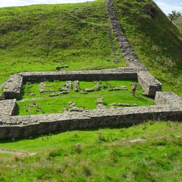
[00:21:09] Don't touch any other parts of the wall anywhere else, or I will personally come and, I don't know, yell at you. Anyway, there are some really nice bits of wall and some nice Roman structures along this stretch. So one of the things you should really keep your eye out for is Mile Castle 37 on Cuddy's Crags. There's not that much of it left, so you'll need to pay attention as you're walking past, but what's really exciting about this Mile Castle is that you can see parts of its north
[00:21:38] gate, which are still there in situ. So what you'll see are a bunch of large blocks that once supported an archway, as well as some of the stones of the actual archway itself. And that makes it really easy to imagine the actual gate that this structure once supported. And if you really stretch your imagination, you can also visualize the tower that probably stood over that gate way back in the second century. Now, as you get through these crags and you finally get to the top of Hot Bank Crags, you're
[00:22:06] going to get some really fabulous views. And maybe some of the best views you get on the whole trail. So to the east, you can see the full line of crags that you've crossed all the way back to Sewing Shields, which are sort of lurking in the background. And to the west, you've got another great view. You'll be able to see a charming little lake, crag luff nestled underneath the next big roller coaster hump that you're going to have to contend with, High Shields Crags. And in the distance, you'll be able to see the highest point on the path of all.
[00:22:32] That's the top of Windshield Crags, which tops out at 345 meters. So after you finish admiring this view, you've got to go down and tackle your next section of this sort of roller coaster, which is High Shields. When you get to the top of High Shields, there are some nice views of the lake, and you actually might even see some rock climbers out there on the north side, depending on the season. The high point here is what happens when you get to the west end of High Shields Crags. Basically, you descend into one of the most well-known landmarks of all along the wall,
[00:23:01] and that is Sycamore Gap, which you'll find a couple of miles west of House Steads in a dip between High Shields Crags and the next hills you've got to contend with the Peel Crags. Now, Sycamore Gap is named, not surprisingly, for a large distinctive sycamore tree that grew there. It was over 100 years old, and it was literally right next to the wall. It had been planted by John Clayton, and it is sort of famously featured in an early scene
[00:23:28] from Robin Hood, Prince of Thieves with Kevin Costner and Morgan Freeman, where they're right there by the tree. They're walking on top of Hadrian's wall in the movie, which made us, like, freeze when we saw it. Well, yeah, because actually that section there right in Sycamore Gap is one of the very few sections of the wall that actually preserves the original Roman dry masonry. Yeah. Maybe laid down in Hadrian's time, maybe laid down a little bit later when Severus campaigned
[00:23:56] in Britain during the early third century. It's a little hard to tell, but it makes my skin crawl to see people actually climbing on that. Yeah. And if you're interested, it also shows up in the Brian Adams video, Everything I Do, I Do For You, that went along with the Robin Hood movie. Ah, the 90s. Ah, yes. And now this is probably the one site on the wall that we heard about the most from people, especially on that first trip. Everyone was like, oh, Sycamore Gap, oh, Sycamore Gap, oh, it's in Robin Hood.
[00:24:25] It got quite built up. But by the time we saw it, in all fairness, it is one of the most photographed trees in the UK, and it is the most popular photo location in Northumberland National Park. And it is quite pretty. Yes. Or it was. It was. We'll get to that in a second. So photogenic, in fact, was the tree. And famous. And famous. And it won England's Tree of the Year competition in 2016. Yes, England has a Tree of the Year competition. It's for a good cause.
[00:24:55] There is prize money given out, and that prize money is generally used for conservation. The next year, it also took fifth place in the European Tree of the Year competition. See, it's not just England. It's not just England. But this story, however, has kind of a tragic twist to it. About two and a half years ago, actually September 28th, 2023, two men from Cumbria who were in their 30s cut the tree down overnight. I don't think we've ever gotten a motive from them other than they were just, well, let's
[00:25:24] say jerks. It wouldn't surprise me if there was a lot of alcohol involved in this too. Yeah. Just a guess. Maybe. But last year, they were sentenced to four years in prison for criminal damage to the tree and to the wall next to it. Right. They chainsawed the tree, basically, and it came down on a chunk of the wall. So not only- It's original Roman masonry. Yeah. Not only did they kill this gorgeous tree, they also damaged the original Roman masonry. Yeah. The stump itself is still alive, actually, and it's been sending up shoots, apparently.
[00:25:53] And I gather there are also cuttings that have been taken from the tree in an effort to preserve it. But as you can imagine, I mean, it took 100 plus years for that tree to grow in the first place. So it's probably going to take another century or more for that tree to recover in a way that will really capture the spirit. Yeah. They're estimating 150 years for it to be what it was when it was cut down. Yeah. It's still a really popular part of the trail, partly because it is close to house deads, and there's another major parking lot just to the west of it. It's Steel Rig.
[00:26:22] And so you'll still get lots of day trippers coming and wandering through here. And it is like a very lovely little gap, even without the tree. And you can see the stump, and they now put a little fence up to protect it. At this point, we're going to take a little digression from the wall itself, as do many hikers, because not too far away from Sycamore Gap, you'll find two interesting landmarks that you can visit. The first of these is the Twice Brewed Inn. This is a combined hostel, pub, and brewery put together into one convenient package.
[00:26:52] Now, chances are you're going to end up staying here for a night on your trip along the wall, partly because there aren't a lot of places to stay through this section of the wall path. And you know, it's not a bad option. The food's pretty good. The beer's pretty good. The brewery itself is a relatively recent addition, so it wasn't there during our first trip in 2010. So in 2010, the pub instead served an interesting, and I dare say Cam misses it, collection of beers from the north more broadly.
[00:27:20] Yeah, I mean, their beer is good, but I did like having the selection of stuff made by other breweries across the north of England and the southern parts of Scotland. Yeah. But secondly, and more importantly, the other site near Sycamore Gap just off the wall is Vindolanda, the site of a series of forts. The Romans first built a timber fort here in the 80s, probably while Agricola was still a governor in Britain and was actively campaigning in the north.
[00:27:47] Now, this first fort was built as one of several forts along the Stain Gate, part of which you can still see just east of Vindolanda, and there's still a standing Roman milestone there marking it. Yeah. On the Vindolanda grounds, there's a replica of the milestone. But if you go tromping off just to the north and you have to kind of go through a little creek bed, there's an actual honest-to-God Roman milestone. It's about five feet tall. It's just sort of planted there in the woods. Yep.
[00:28:13] It's unmarked, but it was clearly one of several milestones that would have led people along the Stain Gate, which again ran from what is now Corbridge all the way to Carlisle. And precisely because the fort here at Vindolanda did occupy such an important position right along this communication artery, it ended up getting rebuilt and renovated many times over its life.
[00:28:37] So you can trace in the archaeology a series of timber forts in the 1st and 2nd centuries CE. And then starting in the 3rd century, you can trace a series of stone forts. Now this fort was home to a bunch of different auxiliary units, including for a time the Tungrians who later moved to Hausteads. And what archaeologists have found here are lots of excavated remains of the kind you'll see
[00:29:05] all of the other forts in Hadrian's Wall country. Yeah. And what's interesting here is the excavations are still active. So if you visit in the summer, you may actually see people digging, which we did while we were there. And that means there's a constantly evolving collection of foundations and things like that to explore, along with some reconstructed buildings that give you a good sense of what structures along the wall looked like. Yeah.
[00:29:30] And this includes replicas of both timber and stone fort segments, which allow you to appreciate the different looks of the fort at various stages in its history. And I will point out, the signs around the fort of Vindolanda are in multiple languages. So I think it's English, German, French, and then most importantly, Latin. Yes. So if you want to practice your Latin, this is a great site to do it at. Oh, I nerded out on those hard. Yeah, it's fun.
[00:29:57] But above all, this site is famous not just for its building remains and not just for these signs that also feature Latin, but also because the site itself has anoxic soil. There's a very strange reason for this that I don't fully think I understand. It has to do with what kind of mosses grow in this area. But because the soil is so anoxic, this site has preserved a bunch of organic artifacts,
[00:30:25] many of which are now housed in the fabulous and recently renovated site museum. Now, this is the kind of stuff that just normally does not survive. So leather goods, textiles, things like that, that are just so rare to find. Including lots of shoes, as I recall. Shoes, yeah. Yeah, like lots of leather shoes. Yeah. And then there's other finds that you would expect, like terracotta and things like that. But some of my favorite things that they have there are like terracotta tiles, just generic tiles where there are prints in them.
[00:30:55] So there's like cat footprints on one. Yeah. Like cat clearly walked across someone's stuff. But my favorite had a handprint in it, like a human handprint. And it was just this idea of being able to sort of reach out through the ages and touch that. I mean, you couldn't because it was behind glass, but nonetheless, like it looked like they'd been made yesterday. Yeah, that was a nice piece. But what really elevates Vindolanda and turns it into a historic or archaeological site of
[00:31:23] world importance is the survival there of a bunch of writing tablets from the first century CE. So pre-Hadrian's Wall. Yes. Now, what these are, are very thin sheets of wood that could be folded in half. And what people would do is write on them in ink, fold them in half, and then send them or store them, depending on whether this was a letter or something to be put into an archive.
[00:31:47] And this sort of thing was probably a standard piece of writing technology in the Roman world, alongside things like papyrus documents and wax tablets. Anyway, the wooden tablets here, covered in ink, are the earliest surviving pieces of writing from Britain. Now, as we mentioned, these date from the first century, probably the late first century, the 90s CE. And at this point, the Fort of Vindolanda is a timber fort, and it's housing the cohorts
[00:32:17] known of Bataworum, so the ninth cohort of Batavians, which is a mixed unit of auxiliary infantry and cavalry recruited from what is now the Netherlands. And they were commanded by a man named Flavius Carialis, who's a Batavian aristocrat who'd acquired Roman citizenship, either personally or through his father. Auxiliaries were normally commanded by Roman citizens serving as prefects, but not normally by people of their own ethnicity. Yeah, so this is a little bit unusual.
[00:32:44] And you have to imagine that either he or his father had done something to merit that kind of post. Anyway, what these wooden tablets mostly are, are lists, accounts, letters, things like that. And they're stuffed full of all sorts of details of fort life in this period in which the Batavians were resident at Vindolanda. Now, one of the best knowns of these letters is a letter to Carialis' wife, Silpicia Lepidina,
[00:33:13] from a woman named Claudia Seguera. And it's a birthday party invitation. And now what's kind of cool about this letter is that, one, she calls Silpicia sister, even though we know that they probably weren't sisters based on their names. So you have someone using a familial term for someone who is a close friend to call them, you know, my sister. But also, this letter is written in two different hands. So we can look at it and tell two different people wrote this letter.
[00:33:41] So what probably happened is that Claudia's scribe wrote the bulk of it, right? She told him or her, I guess the scribe could be a woman, what to write. And then they wrote it out. But Claudia herself added the closing with her own hand and signed her name, basically. And if that is accurate, then this is the oldest surviving piece of writing. In the world, like actual physical writing that we can say for sure was written by a woman. Yeah.
[00:34:10] We have a bunch of other documents like this from Roman Egypt, but they all post date this letter as far as I know. Only slightly less well known in this collection is a letter that I really like. It's a letter to the commander, Kerialis, from a junior officer named Masculus. And Masculus is writing to ask for some follow-up orders. He was apparently on some kind of detachment with some of the fort's soldiers somewhere. We don't exactly know where. But what's really funny here is that he ends the letter by telling Kerialis that he and
[00:34:37] his men have run out of beer and would very much appreciate it if Kerialis could send them some more. I mean, nice to know that things haven't changed. Yeah, yeah, yeah, yeah. And what's also kind of interesting here is that we are still in the beer belt. Yeah. They're not drinking wine, which is what they would be drinking further south on the continent. They're drinking beer instead. Well, it's probably what you could get locally. Yeah, exactly. What can we ferment that grows locally? Grain? Okay, we'll cope with that.
[00:35:05] Anyway, a bunch of these writing tablets are in the British Museum. So if you happen to be in London on your trip over to the UK, make sure to stop by and see them. It's something they haven't looted from elsewhere. They've looted it from their own country. We shouldn't bash the British Museum too much. But, happily, a small collection of these writing tablets are now on display at Vindalanda itself in the newly refurbished museum. Yeah, that Canadian accent's coming out there. Yeah.
[00:35:31] So, now that we've taken this digression from Sycamore Gap, we're going to circle back to the wall and pick back up on the path heading westward again. So as a reminder, at this point, we've been in the crags for almost six miles. Right. That's just under 10K, although it feels a lot longer than we're actually walking. Yeah, the crags, that walking feels really long. Yeah. There really are a lot of up and downs.
[00:35:58] And sure, you may be used to hiking, but that kind of just going up, down, up, down, up, down gets tiring pretty quickly. Yeah. Especially when you're carrying 20 to 25 pounds with you, which we don't recommend. But we'll get to that later. Now, we have good news and bad news for you. The bad news is that from Sycamore Gap, there's still another six and three quarter miles or so of crags to tackle. That's almost 11 kilometers. The good news, though, is that this whole section features some really spectacular views
[00:36:27] and a whole bunch of interesting things to see, including lots of great chunks of wall. Yeah. So over that six and three quarters miles, you're going to get a series of five crags. The Peel Crags, the Windshields Crags, the Caulfields Crags, the Mucklebank Crags, and the Walton Crags. Yeah, it's a lot. It's a lot. It seems to just go on forever. Yeah, that's really what I remember from this part. So coming out of Sycamore Gap, you first tackle the Peel Crags.
[00:36:55] This section of the trail is best known for Mile Castle 39. That's the 39th mile castle along the wall starting from Sagadunum in the east. Locally, it's generally just called Castle Nick. And this section, this mile castle and the sections of the wall that flank it were consolidated by English Heritage. And so it's actually pretty tall now. It's up to 10 courses of stones in some areas. Yeah, that gets it up almost to six feet, basically. Yeah.
[00:37:20] And importantly, because Castle Nick sits in this little saddle in the Crags, you get a fantastic view of it from above. So this turns out to be a great spot for a photo because you can really see the outlines of the fort and how it is situated in relation to the wall. It's also cool because you can actually make out some of the internal structure. These mile castles, as I've mentioned a couple of times, were garrisoned by probably around
[00:37:46] 30 soldiers that were living there probably in fairly tight quarters, sometimes along with horses and things like that. And they were basically just there to keep an eye on things. But it's really cool to be able to see how that mile castle was laid out on the inside. And so from there, you know, the path continues on and you get sections of wall that are consolidated wall, sections of wall that are Clayton wall. Some of them are just field wall built on top of the line of the Roman wall as you go over the Crags. Things get really fun once again after the path comes down from the Peel Crags because
[00:38:15] at that point, it begins its run up the Windshields Crags. And the Windshield Crags feature the highest point on the whole trail. Tops out at 345 meters. That's over 1,130 feet. But when you get to the top, of course, there are spectacular views. It's like gorgeous countryside as far as you can see in every direction. And it's a great time to stop and rest and enjoy the view. And you are going to need a break here because it's a long climb. So make sure you savor it.
[00:38:45] Because, of course, you're going to have to go down the other side. And then there's just more of the same as you tackle the Caulfields Crags next. Although what you do get from here, interestingly enough, are excellent views of the Valum, which parallels the wall to the south. We've talked about this before, right? This is a feature that consisted of an earthen bank, a big ditch, and then another bank that ran on the south side of the wall and created a kind of exclusion zone on the quote-unquote
[00:39:11] friendly side of the wall to make it easier for Roman forces to move fort to fort. And you can see it in a number of places as you hike the wall. But here, it's close enough to the path to be really, really obvious. And there's also a quarry, Caulfields Quarry. The Romans probably quarried stone here back in the first, second, and third centuries. But most of what you'll see is the result of modern 19th and 20th century quarrying that unfortunately destroyed a big chunk of the wall.
[00:39:38] The quarrying did, however, leave behind a really pretty lake that makes for great pictures because you can actually get the crag reflected in the surface of the lake, although you are not supposed to swim in said lake. No, it's apparently very, very, very cold. Yeah. Anyway, after Caulfields, you get one major last run of crags, and that's the Walltown Crags. In theory, there should be no sweat after what you've just been through. But if this is the end of a long day, it's going to hurt.
[00:40:07] The upside, though, is that this stretch features some really, really great sections of consolidated wall, especially toward the west side of this series of crags. And this is where we actually had kind of a funny encounter on our first trip with what we think were a professor and some grad students. So we were walking west, they were walking east. And what you had were three people, one of whom was not quite wearing tweed, but almost wearing tweed. Pretty close, yeah. And it was just carrying like a little folder with him.
[00:40:38] And then you had two younger people who were carrying massive giant backpacks, including the young woman who looked like you probably could have fit her in the backpack she was carrying, trudging up the crag behind him. And, you know, the professor's just like, whatever, didn't talk to us, basically ignored us. And then the two other people with the bags were like very friendly and said hi, and you know, as you do. And we were joking. It was like, that just reads as professor and grad students, just everything about it.
[00:41:06] And when we got to the next crag, we took a break and we stopped and we could see them on the previous hill. And they had stopped to take a break. And, you know, professor was in full on pointing out mode. Yeah, full on pointing mode while the graduate students pretend to be listening. They sort of sit there and recover after lugging their 50 pound packs. Carrying everything for both. Yeah. I felt pretty bad for them. But they seemed in good spirits, in all fairness. Students who complained about how much walking I made them do at archaeological sites have
[00:41:35] no idea how much worse things could have been. And from here, the really rough section of the path is over. You come down the far side of the walltown crags to another quarry, because as is the case at Caulfields, this area has long been mined for windstone. Now, it's worth mentioning that just off the trail here, you're going to find something worth stopping at, which is the Carverin Roman Army Museum.
[00:42:01] This has been built more or less at the site of a Roman fort, originally called Magna or Magnus. And this was one of the forts built by the Romans along the Stain Gate in the 80s. This museum is part of the Vindolanda Charitable Trust. And as such, it hosts a bunch of finds, many of which come from Vindolanda, including a very rare surviving helmet crest. And then, of course, it also features a bunch of replicas of Roman military equipment and so on.
[00:42:28] The museum tells the story of a Roman soldier, what life was like as a Roman soldier, what it was like to be a Roman soldier. And it both tells it from sort of a general empire-wide perspective, all the way up through things like daily life on the frontier. And it specifically includes information about a unit that was stationed here at the Magna Fort. It was a unit of Syrian archers, the Cohors Prima Hamiorum Sagittaria.
[00:42:55] And this is actually the only regiment of archers that is known to have been stationed in Britain. And like our friends, the Tigris rivermen who were stationed at Arbea, these were people who were literally transported from one side of the empire to the other. Yeah. Right. From one climate to a completely different climate. So it's interesting to just sit there and as an exercise for the imagination to think about their perspective. What was it like to move from one imperial frontier to another?
[00:43:23] And this museum, like the Museum of Vindalanda, was modernized and revamped between our two visits in 2010 and 2018. Currently, they are in the process of doing excavations around the fort there. And recently, they found a cremation cemetery in the northern mound of the Valum. And this is the first time that burials of any sort have been found in the Valum itself.
[00:43:49] And so the unusual location suggests that the people during the burials were not local, either Roman or British, but perhaps represented a more transient population. And this is just a really cool reminder that there's a lot we don't know yet about life on the wall and that archaeologists are still making new and interesting finds. And I just saw recently that a few months ago, February, archaeologists found a terracotta
[00:44:14] head of a woman, seems to have been manufactured in the third century with what they're describing as asymmetrical features and crude execution, which may be a practice piece. You can imagine an apprentice basically creating molds for terracotta and perhaps not doing such a great job on the first couple of iterations. Yeah, I think that's what the archaeologists have speculated, quote unquote, practice piece made locally by an unskilled hand.
[00:44:41] Yeah, you know, you find these sorts of things from time to time in context that are clearly workshops. So I'm thinking of a great site from Turkey where you've got a sculptor's workshop containing a bunch of pieces, including pieces that were clearly carved by people who were learning. You can tell just because the carving is hesitant and the quality is not great and so on. And I can totally imagine that this is sort of the same thing. Yeah, it's a cool find. Yeah.
[00:45:06] And the museum is also in the process of building an extension that's going to sort of have this like all glass wall that's going to enable people from the museum to view the fort site itself. And because you're on kind of elevated ground here, you'll actually have views all the way to the Solway Firth, which would be the western terminus of the wall. Yeah, because of course, here we're through the crags and the rest of the path is mostly downhill with the occasional up again, just to sort of keep you on your toes.
[00:45:35] And that's because here at the end of the walltown crags, the path has basically reached the western margins of the Great Wind Sill. So the terrain as a whole becomes a bit more gentle after this. Yeah, there's really only one major climb left. It's a little over three miles down the road. And this is where the path dips down into the valley of the Earthing River. And of course, going down into a river valley means you have to climb up out of it on the
[00:46:02] other side. And it actually is a really steep climb where you gain about 40 meters pretty quickly. To compensate you for that, the path on its way to the Earthing does cross a couple of pretty interesting spots where you can stop and look and take pictures and see some cool stuff. The first of these is Thurwall Castle. This is a castle built in the 12th century, probably expanded a couple hundred years later in the 14th century. And in both phases of its construction, the builders used a whole lot
[00:46:32] of stones plundered from the wall. So what you're looking at is a castle built out of repurposed wall stone. These days, it is a spectacular and very picturesque ruin. Some stretches along the path here also route you through the wall's north ditch, which gives you a really good sense of how deep it is when you're walking through it. Yeah, it's really, really forbidding, right? I mean, it's not something you would want to cross if you were trying to make a sneak attack on the front side of Hadrian's Wall.
[00:47:01] Now, when you get to the Earthing River itself, you'll be able to see the eastern abutment of the Roman bridge that once crossed the river called the Willowford Bridge. Now, because the river has shifted course westward over the centuries, the eastern abutment is pretty far away from the river now, and its companion abutment on the west side has been completely washed away. Now, to be honest, this bridge abutment is a little hard to understand if you aren't an archaeologist.
[00:47:29] It just looks like a big pile of blocks, basically. But what's really interesting here is the scale. It gives you a sense of how big and impressive that bridge would have been. Now, these days, the Earthing is crossed by a modern footbridge, and then you get a steep kind of switchback ascent up the really steep hill to rejoin the wall at Mile Castle 49. And this actually is a really significant spot. As we mentioned when we did our overview of Hadrian's
[00:47:54] Wall a couple of episodes ago, Hadrian's original plan seems to have called for a turf wall in the west and a stone wall through the central sections and the eastern sections. And the place at which the turf wall and the stone wall met was essentially here on the west bank of the River Earthing, right around where Mile Castle 49 now stands. Now, as we mentioned, those turf sections were later rebuilt in stone within a couple decades of
[00:48:22] their initial construction. And the final stretch of today's episode from here to a fort now known as Byrd Oswald actually features some really nice bits of consolidated wall. Yeah. And as you're walking through, the highlights you should keep an eye out for are definitely stones that carry the marks of the builders. So there are a couple of centurion stones. These are stones that basically name a centurion and the cohort he commanded. And they're usually
[00:48:52] stones that were probably incised more or less on the spot as people were building the wall to keep track of who had done how much work. But then there are a couple of really interesting stones with relief carvings on them, mostly phalluses, probably aprotropaic, right, to ward off evil. And both these and the centurion stones are mostly at eye level. So if you keep your eye peeled, you'll probably see them as you're walking between Mile Castle 49 and the fort at Byrd Oswald.
[00:49:20] And so finally today we come to the fort at Byrd Oswald. What in antiquity had been known as Bana, which probably comes from the Celtic word meaning peak or horn, where 59 miles along the trail from the east, or about 50 Roman miles along the length of the wall. Now this fort, Bana, really anchored the wall on the west side of the earth thing. So it was there to sort of keep an eye on this point a little bit to the east where the stone wall gave way to the turf wall.
[00:49:49] And it had been occupied, we know for sure, by the Cohors Prima Aelia Decorum, as well as other auxiliary units. Now this Cohors was a unit from Dacia, what is now Romania. And we know that they were for sure stationed at this fort from at least 126 until at least either 276 or 282. There's some dating issues there with the inscriptions. But we actually suspect that this unit was in Britain until the Romans withdrew in the early 5th century.
[00:50:19] So within Byrd Oswald, what you'll find are the remains of the kind of buildings that you will have this point seen all the way along the wall. There are gatehouses, some pretty good ones actually still in situ. There are granaries, you know, typical fort buildings, the remains of a bathhouse found nearby in the river valley. But what's really cool here is that all of this is attached to what is the longest surviving stretch of wall that now stands, built within a couple of decades of
[00:50:47] Hadrian's own visit to Britain in order to replace the turf wall that had stood here in the 120s. Now what makes this spot actually really unique is that when the turf wall was replaced, a change was made to the location of the wall here. And this is the only spot where that happened, in that the location of the wall between the turf wall and the stone wall was shifted about 50 meters
[00:51:11] or 160 feet to the north. What they think was going on here was that the turf wall had basically lined up with the east and west gates of the fort. And when the stone wall is built, it is built further north to align it with the fort's northern wall. Now what this means is that this is also the only area where today we can actively compare the turf wall and the stone wall. So that's one really cool aspect of this fort. But Bertuswald has also been important for other
[00:51:40] reasons. And one of the things that archaeologists have been excited about here for years is photo altars, the kind of altars that you find everywhere along the wall, dedicated by soldiers with a little bit of money to spare to gods in the hope of winning that god's favor. A lot of the ones dedicated in Bertuswald seem to be dedicated to Jupiter. But we found at least one dedicated to a Celtic god,
[00:52:04] Cocidius, who seems to have been a god presiding over war, hunting, and forests, and who seems to get assimilated to the Roman war god Mars. As well as Silvanus. And I think it's not too far actually from Bertuswald on the north side of the wall that there was a major sanctuary to Cocidius in pre-Roman times. So part of the argument that is going on here is that the Romans intentionally tried to sort of placate this particular god in part because that god seems to
[00:52:33] have been so important locally. And what the Romans are trying to do is to draw that power to themselves rather than leave it in the hands of potentially hostile neighbors. One of the other significant elements about this fort is that it's the only site on the wall that shows significant occupation after the Romans leave, and possibly until 500. So really for about a century after the Romans pull out of Britain. And it's thought that this was a power base for a local war
[00:53:01] band, possibly one that was actually descended from the Roman garrison, and thus is sort of deriving legitimacy as rulers from their ancestors in the Roman army, which is just kind of an interesting sort of thing to think about. It's entirely plausible, right? That's the sort of process that in the minds of a lot of people, gives rise to people like Arthur. If Arthur was based on a real historical person, as some people argue that he was. The last thing that's worth saying about Burtiswald, just because it's going
[00:53:30] to connect with something we'll revisit in our third and final episode in this travel log... And you'll see it when you go. Right. And you'll see it there, very, very prominent, is the big basal house that dominates the site. That's B-A-S-T-L-E. This is essentially a strongly fortified farmhouse. And the example here at Burtiswald was built in the 16th century. It was built at a time when the border region between
[00:53:58] England and Scotland to the north was, for lack of a better term, pretty lawless. And when there was a lot of cross-border raiding in each direction by people who are usually called reavers in the scholarship. And when you go to Burtiswald today, most of what you're going to see was created by a man named Henry Norman in 1849 who owned the property. And he both built some additions onto the farm buildings. And he also excavated the fort there. Another lover of antiquities.
[00:54:27] Yep. The farm buildings are still there. And there's a cafe and bathrooms and all those things. There's also a youth hostel in one of the farm buildings. We did not stay at the youth hostel. We actually stayed in Gilsland on our first trip. So what we did was we walked through Gilsland, came to Burtiswald, and then went back to Gilsland to stay overnight, which was not the greatest idea on a day in which we'd also been tackling the back half of the crags.
[00:54:54] Yeah. Luckily, the woman the next morning offered to drop us off at Burtiswald so we didn't have to do that climb back up out of the river again. Yeah. And her B&B was a great little place. They also did dinner. But because I was foolish, I did not book dinner in advance. So we were on our own. Which was fine. There was a pub in town. We could get food. However, we had a distinctly bad food experience at this pub. This is probably the only really bad food experience we had along Gilsland's Wallet. It was the worst food experience we had for sure. You know, the beer was fine. They had real ale.
[00:55:24] Yeah. The food was fine. It was just like a steak and ale pie or something probably. Yeah. They had cheesecake on the menu for dessert. Now, I like a good cheesecake. Nobody warned me about this. Cheesecake in the UK is not the kind of cheesecake you're expecting. And so we ordered it and it looked and tasted like yogurt pie. Yes. That's the best I can describe it. It had that tang of yogurt. It was kind of runny. It was
[00:55:52] not good. It was so disappointing. That story is going to come back around later in this travelogue. Yes. The north of England at the time was not good for his cheesecake. That's for sure. Stay with the sticky toffee pudding. Yes. That's where we're going to wrap things up for today, for this episode. Right. We'll come back with a final episode on this travelogue that will get us from Burtiswald to the Solway Firth, a distance of about 25 miles along the trail. So I've been Emily.
[00:56:21] I'm Cam. And this has been Have Toga, Will Travel. If you liked this episode, and who wouldn't love that rousing discussion of yogurt pie at the end, please tell a friend about us. That's one of the best ways you can support the show and help us grow. Subscribe to our show wherever you get your favorite podcasts and follow us at havetogowilltravel.com or on all the socials. Thanks for listening, everybody. See you in a couple of weeks. Bye.