Curious to know what it’s like to walk the length of Hadrian’s Wall in northern England and experience the monument the way the ancient Romans did (on foot!)? Join Emily and Cam as they describe what there is to see and do along the first 38 miles of Hadrian’s Wall Path National Trail. You’ll hear about Roman soldiers from Mesopotamia, a Smell-o-Rama (yes, really!), the modern worship of the ancient god Mithras, and what Cam thinks about Real Ale (spoiler: he loves it!).
Visit our homepage to subscribe, to find us on social media, and to contact us by email:
----------
00:10 - Introduction
00:44 - Hadrian’s Wall Path
- 01:34 - Our experience on the Trail
- 02:12 - The history of the Trail and the English footpath system
- 03:32 - How we came to walk the Wall
- 05:00 - The three main sections of the Wall
06:20 - Arbeia (South Shields)
11:53 - Wallsend and Segedunum
- 12:02 - Latin everywhere!
- 12:44 - Exploring Segedunum Roman Fort
- 15:35 - The Wall Passport and Segedunum’s guest book
16:53 - Newcastle and Newburn
- 16:59 - Tyneside and its industries
- 18:26 - The bridges of Newcastle
- 19:49 - Newburn: Keelman’s Lodge and Big Lamp Brewery
- 21:48 - Cam’s digression on Real Ale
22:58 - Heddon on the Wall
27:19 - The Portgate and Dere Street
- 28:25 - A digression on Sticky Toffee Pudding
29:50 - Corbridge and Corstopitum
- 30:25 - A strategic junction: Dere Street, the Stanegate, the Tyne
- 31:50 - The Roman site and the museum
- 33:43 - Getting to Corbridge from the Wall
- 33:47 - Making friends along the trail
37:00 - Heavenfield
38:38 - Planetrees
40:55 - The North Tyne, Chollerford, Chesters
- 41:22 - The Roman bridge across the North Tyne
- 42:26 - Chesters Fort: the site and its inhabitants
- 45:54 - Greencarts, the AD122 bus, and why doing the Trail in 2 days is a bad idea
48:15 - The Mithraeum at Carrawburgh
- 49:34 - Mithras: the Romans reimagine an Iranian god
- 50:07 - Mithraism and other mystery cults
- 51:19 - The Mithraeum and its remains
- 52:14 - An encounter with a modern devotee of Mithras
54:55 - Wrap-up
Hello. Welcome to Have Toga Will Travel, a podcast exploring the Mediterranean world, ancient and modern, through the eyes of two former classics professors. I'm Emily.
Cam:I'm Cam.
Emily:And we're your hosts.
Cam:So welcome to part two of our series on Hadrian's Wall. If you haven't listened to part one yet, you should go back and do that. It's a great episode. We talk a lot about the history of the wall, its context, how it got there, what it looked like in its glory days. This episode is going to be a little bit different. This is going to be the first in a series of travelogue episodes in which we describe our own experiences hiking along the wall.
Emily:So we've done this hike twice, once in late summer in 2010, and we hiked east to west. And then we did it a second time in late spring in 2018, where we hiked the other way from west to east. Now, I think we liked the second route better, going from west to east, because you get to end at Newcastle and the Segedunum Fort that we're going to talk about, and there was a lot to do.
Cam:Yeah, ending in Newcastle is a lot of fun, because among other things, it's great to have access to a whole bunch of pubs and things when you've just finished an 84-mile walk.
Emily:Yes, it's very true. However, for the purposes of these podcast episodes, we're actually going to talk about the wall from east to west, since that's the way in which the route is usually presented. And also we have better notes and pictures from the first trip than we do from the second trip.
Cam:It's definitely a great trip, either way you decide to walk it. The hike is about 84 miles along a well-defined trail that stretches from Newcastle upon Tyne in the east to Bowness on Solway in the west. It mostly goes along footpaths that parallel the 80 Roman miles that defined the course of Hadrian's Wall itself. A Roman mile, once again, is a little bit shorter than a modern mile, so the wall in its finished state ran for about 73 miles altogether. The wall trail these days is a little bit longer just because it diverges from the actual line of the wall in a few places.
Emily:Now, the Hadrian's Wall Path, which is its formal name, has been designated as a national trail in the UK since 2003. and these days it is maintained by a group called Natural England, which is an agency of the UK government.
Cam:And they do a great job maintaining the trail.
Emily:They do.
Cam:But interestingly enough, that trail is stitched together from lots of pre-existing public footpaths. These are routes, sometimes centuries old, which cut through public lands and private property, but over which the public has rights of way.
Emily:These public footpaths exist all over the place in the UK. They also have public bridle paths, which you can take horses and bikes on. And so it's actually a really cool thing to take advantage of when you're traveling in the UK is these public footpaths. Of course, when you do so, you should be respectful of the property that you're on.
Cam:Right, because a lot of it is privately owned property.
Emily:So yeah, don't be jerks about it. But it is a really cool thing. And they're signed and they usually tell you how far it is to different places. It's cool. Now, a good chunk of the Hadrian's Wall Path Trail actually lies within the Northumberland National Park, as well as traversing a lot of privately owned property, mostly farmland.
Cam:Now, weirdly enough, when we first did this in 2010, it was Emily's idea.
Emily:Yeah, this is not the kind of idea that I normally have. This was— this sounds like it should be a "Cam" idea, but it wasn't.
Cam:Well, you ran across a discussion of the trail in a blog somewhere.
Emily:Yeah, someone's blog was talking about hiking it, and it sounded like fun.
Cam:It did sound like fun. I think your approach to this was to just go.
Emily:Yes.
Cam:I insisted on planning it a little bit.
Emily:Yes. That was probably—no, that wasn't probably, that was the smart thing to do.
Cam:Yeah. I'm glad I did some planning.
Emily:Me too.
Cam:Because it is kind of busy in high seasons.
Emily:Yeah.
Cam:And by busy, I mean, you'll run into a few dozen people on the trail every day. But there's not a whole lot of lodging along the way. So if you want to do a proper through hike, stopping at a different place every night, you've got to plan that in advance a little bit.
Emily:Yeah, and book your lodging. It is worth pointing out that this hiking trip, this trail, is not something you can do year-round, or you're not supposed to do year-round. To protect the trails from erosion and wear and tear, they request that you only use the trails from May to October and not in the wetter season of the late fall, winter, early spring.
Cam:And that's part of what makes it busy in the summer, that along with school holidays.
Emily:Yeah.
Cam:We'll circle back to the logistics of how the trail works, probably towards the end of our travelogue.
Emily:Yeah.
Cam:That might be next episode, might be the episode after. Our original plan had been to produce a two-part travelogue, and that may be what we still end up doing, but as we've been sort of drafting an outline, we've realized that there's a lot of stuff to say, so this might actually end up being three episodes.
Emily:We'll see what happens.
Cam:Yeah, it depends how long I babble nonsensically about stuff, I guess, right?
Emily:How much do you want to know about the Roman military?
Cam:Right, yes. But let's talk about the path.
Emily:So the path itself can be divided into three sections. All wall path is divided into three parts.
Cam:Yes, right.
Emily:Anyhow, so yes.
Cam:I'm sad that people who've never read Caesar will never know how nerdy that joke was.
Emily:So three sections. So the first section of the wall as you move from east to west is this section from Newcastle, or technically Wallsend, which is a suburb of Newcastle where it starts, to the southeast corner of Northumberland National Park. This is a relatively level section of path of about 38 miles, and it goes over gently rolling terrain with the exception of a couple river valleys that entail a little more climbing.
Cam:The next 14 miles of the trail make their way along the southern edge of the Northumberland National Park as far as the valley of the River Irthing. This chunk is defined by the Crags, and that's a real roller coaster of ups and downs.
Emily:The Great Whin Sill that we mentioned last time.
Cam:Yes.
Emily:The third section of the path is the final 32 miles or so from the River Irthing to the Solway Firth, where the trail ends. Now, the plan for today is to talk about that initial chunk of those first 38 miles.
Cam:And then, yes, we'll deal with the rest in either one or two episodes, depending on how long exactly this takes us.
Emily:Yes. Although we're starting pre-wall, I should say.
Cam:Right. Because any visit to the wall, especially if you're starting in Newcastle, really benefits from a visit to South Shields. That is another Newcastle suburb, this one a little bit to the east of the city and on the opposite side of the Tyne River. And what you'll find if you go to South Shields are the remains of a Roman fort, a fort which we now usually call Arbeia, which is built at the mouth of the Tyne River, about four miles away from Wallsend, again on the south side of the Tyne.
Emily:Now this fort has a long history. There was probably a timber fort on the site in Hadrian's day to guard the river approach. It then gets rebuilt in stone in the 160s CE when the Antonine Wall is abandoned and they regarrison Hadrian's Wall.
Cam:For much of its life, that fort housed Roman auxilia soldiers. The Roman army had a couple of different kinds of units in Hadrian's day. There were the legions, which were staffed by Roman citizens, who signed up for a 20-year hitch. And then there were the auxilia, which were staffed by non-Romans generally recruited from regions that had been annexed to the Roman Empire relatively recently. They signed up for 25-year hitches, after which they would earn citizenship. Here at Arbeia, at least in the 2nd and 3rd centuries, it looks like there were probably about 600 soldiers: 120 cavalrymen, and about 480 infantrymen.
Emily:Now, in the late empire, we know that there is a unit stationed here from Mesopotamia, and specifically from the Tigris river. And that's actually where the fort takes its name Arbeia from. Arbei a comes from the word for Arab in Latin. And this unit was brought there specifically to pilot boats on the river Tyne. Mesopotamia, of course, has the Tigris, which is the area where this unit is from, and they were skilled boatmen. Now, I remember seeing something on our first trip that there was also auxiliary troops from Egypt there, which of course is another area known for its river, right, the Nile, and there would have been skilled rivermen there as well. However, we can't actually find any documentation now that supports that. But we do know for sure that the Mesopotamian soldiers were there. And for me, I just I kind of imagine what it would be like to be someone from Mesopotamia or Egypt, even to find yourself in Northumberland on the Tyne River and what a change that must have been.
Cam:Yeah, it really must have seemed to them like the edge of the world.
Emily:Yeah.
Cam:It was, I'm sure, a whole lot colder than the places that they were used to back home. But it probably also seemed—because it was—a lot less urbanized, right? A lot more wild.
Emily:Oh, yeah.
Cam:So it must have been a real experience to move from these parts of the world to the northern frontier of the empire in what is now England.
Emily:Yes. You've signed up to join the Roman army. You'll get citizenship in 25 years. Oh, and by the way, we're sending you to the furthest place you can possibly imagine.
Cam:Yeah. At the same time, though, this is an interesting bit of evidence that shows you just how multicultural the Roman Empire was, right? And the way that empire is a phenomenon really did create a kind of cosmopolitanism by moving people from one remote corner of the empire to another, not always consensually.
Emily:Yeah.
Cam:You know, and I happen to be somebody who thinks that empire probably does more damage than not, or the damage it does is greater than the benefits it confers. But one of the things it does produce is that kind of cosmopolitanism that brings distant cultures into touch with one another. Anyway, if you go to Arbeia, what you'll find there are some interesting replica structures to give you a sense of what these forts looked like at their prime. So they've reconstructed the West Gate. It's a very impressive structure that shows you just how intimidating these forts would have been if you were an attacker. They've also reconstructed some of the soldiers' barracks, as well as the commander's house. And of course, what you will also see are a bunch of excavated remains of other structures in the fort. And it even has a small collection of artifacts. And in particular, I remember a lot of tombstones with inscriptions and relief sculptures on them.
Emily:Yeah, it was a cool site.
Cam:Yeah, definitely worth a visit, especially since it's relatively easy to get to. There's a metro station, not too far. You know, it'll take you about 10 or 15 minutes to walk there from the closest train station.
Emily:On our first trip, we actually stayed in South Shields the first night, not far from Arbeia. And that actually led to a sort of funny incident on the metro, subway, train, whatever you want to call it, that we used to travel to the start of the hike the next day. So we got on the train at South Shields, which was the terminus of the train. And there was like a teenager that was sitting with his feet propped up on the seat. And of course, there were signs everywhere saying don't do that. An older man had asked him to put his feet down and he like hadn't and there was lots of old men being like, ah, kids these days stuff. The conductor comes by, asks him to put his feet down. He does for like 30 seconds. And then when the conductor's gone, he puts his feet back up and the conductor comes through a second time, tells him again. And then there was some back and forth. And finally, the conductor threw him off the train. And the kid wasn't moving. The kid was like, you can't throw me off the train. And the conductor was like, this train isn't going anywhere with you on it. If you think I'm kidding, just try me. And so the kid got off the train. It was pretty funny.
Cam:There's something pretty intimidating about the Newcastle blue collar attitude. So yeah, the conductor was definitely going to win that encounter.
Emily:Yeah, it was a fun time. So anyhow, we took the metro from South Shields to Wallsend, which is where the wall technically starts. Now I will say this made quite the impression to get off the train at Wallsend because there are Latin signs all over the metro station. Every major sign in the metro station had a Latin version of it. A sign indicating the way to the bus stop. A sign to not smoke, like a no smoking sign. Everything was in Latin. It was so exciting. I was beside myself. And there were pictures of things in Wallsend and you could see like stores that had Latin signs. We did not get a chance to go and poke around Wallsend more, but it would have been really cool. So yeah, I was super excited. It was a great kind of first moment on that day.
Cam:Yeah, so much so that it almost seemed like an anticlimax to get to Segedunum itself.
Emily:That's not totally true.
Cam:So whereas Arbeia was a fort built specifically to guard the entrance to the Tyne River, the fort at Wallsend, called Segedunum by the Romans, was positioned there specifically to be the eastern terminus of Hadrian's Wall. Its remains have been fairly well excavated, and they've turned the whole area into a nice little park that features, among other things, a neat little observation tower that you can ascend, and it gives you a good bird's eye view of the remains, most of which are, frankly, foundations rather than standing structures, but it's still an interesting view and well worth the trip up.
Emily:Yeah, for sure.
Cam:That structure also has a bunch of galleries displaying Roman artifacts taken from the excavations at Segedunum, as well as some other places nearby.
Emily:Yeah, and a lot of these displays are geared towards children, and it's clear they get a lot of school groups there. We saw a few. One of the funnier things they have there is a sniff-o-rama. It's near the gatehouse, and the four smells there are wood smoke, urine, incense, and fish.
Cam:You're probably going to want to explain why urine is in that list.
Emily:Well, generally, the Sniff-O-Rama is there to convey what the big smells would have been had you been there in the ancient Roman period. And urine, other than we don't have great sanitation—right, so you've got public latrines and things like that— but urine was also used to do laundry. The ammonia in urine is very beneficial when you're trying to clean clothing. It will help you clean fabrics quite well. Doesn't smell great, but gets the job done.
Cam:Yep.
Emily:And like at Arbeia, Segedunum also has more replica structures. So there is a replica bathhouse, complete with wall paintings, a replica latrine, a section of the wall, and a reconstructed medicinal garden, complete with a little altar to a Asclepius in it.
Cam:Yeah, the bathhouse is a nice little feature. Most people, I don't think, know how Roman baths worked. So it's kind of interesting to go in and see the different rooms and think about the order in which people would plunge into cold baths, hot baths, cold baths again, and things like that.
Emily:The sweat room.
Cam:Yeah. But in addition to the reconstructed buildings, what you'll also find at Segedunum are some chunks of Hadrian's Wall. This is going to be your first view of the actual structure. As we've sort of anticipated in our last episode, you're not going to see a whole lot of wall along the trip if what we think of as wall is an actual freestanding structure, for the simple reason that a lot of it has been disassembled over the centuries. What you will see are low foundations and courses all over the place at various different stretches. And here at Segedunum, there's a section of wall with about eight courses surviving in spots, which is a lot compared to what else you'll see along the way.
Emily:Yeah. Now, if you're doing the wall and you start here, one of the things you can do is buy yourself a Hadrian's Wall Path passport.
Cam:Yes, the passports.
Emily:Yes, the passports. And there's way stations along the way where you get your passport stamped or stamp it yourself. And if you complete all of it, you can send it in and get a little certificate and patch that says you finished the wall. So this is where we on the first trip bought our passports and got our first stamp.
Cam:Yeah, it's a fun little way to keep yourself motivated where you're just really wanting things to end. And finally, if you start in the west and end at Segedunum, they also have a nifty little guest book that you can sign.
Emily:Yes, for people who finished the wall hike.
Cam:Yeah, just for posterity's sake.
Emily:And now we didn't know that until we actually finished there.
Cam:Yes.
Emily:And we were really done when we finished that second time. And the woman who was working clearly took some pity on us. We walked in and she was just like, there are chairs. You may sit as long as you like. And we discovered that the cafe that we were hoping to use had closed for the day. And so she kindly offered to bring us some water or tea while we sat there and recovered.
Cam:Yeah, it was very nice of her.
Emily:It was.
Cam:And we got to sign the book.
Emily:And we got to sign the book. That was cool. And bought our t-shirts and said we'd done the wall.
Cam:Yeah.
Emily:So now that we've talked about Segedunum, we're going to talk about the stretch of the wall that runs really through Newcastle proper. Now, the first 15 miles or so of the trail does divert away from the line of the wall because much of this section is under Newcastle itself. So instead, the wall path takes the walkers along the north bank of the River Tyne.
Cam:Yeah, and for the most part, this is a fairly nice walk. There are some picturesque bits, in spite of the fact that the whole Tyne estuary and a couple of miles in from the Tyne estuary have really suffered from industrial pollution in the 18th, 19th, and 20th centuries.
Emily:Yeah.
Cam:And in particular, one of the things that gets pointed out to you by interpretive panels as you're walking along the trail is St. Anthony's Tar Works, which was in operation from the early 20th century until the 1980s. Although there had also been previous chemical works in the area going back to the early 19th century.
Emily:Yeah, it's not just interpretive panels. It's also signs telling you, don't go on the beach. It's too polluted for anyone to be down on it.
Cam:Those too, because of course, all of these industries produced all sorts of waste chemicals that have been slowly leaching into the river for decades and decades and decades. And unfortunately, there just hasn't been the funding to conduct the sort of extensive cleanup that you would need in order to restore this to a more usable state. The coal tar and the oil that are sort of products of these industries have permeated the ground. And there's also a bunch of lead from 19th century lead working in the area.
Emily:Yeah. So once you get into like Newcastle proper, of course, there's like all sorts of businesses and stuff along the riverfront. And there's actually a really impressive set of seven bridges that cross the River Tyne in Newcastle. And they make for some really beautiful, like gorgeous pictures.
Cam:Yeah, they're all clustered pretty closely together.
Emily:Yeah.
Cam:In roughly one mile of trail, you'll pass underneath all seven. The oldest of these dates to about 1850. And the most recent, I think, is what they call the Millennium Bridge, which was built in 2001. So it gives you a really interesting historical perspective of the evolution of the city itself.
Emily:Yeah. An architectural history of bridges in one picture.
Cam:Yeah. And as Emily said, it makes for some great shots.
Emily:It does.
Cam:The downside here is that as you're walking along the Tyne from Segedunum, really well past Newcastle, you are walking on asphalt. And that can be tiring. It is a hard surface. And if you're carrying packs in particular, it can really start to irritate your knees and your ankles and so on.
Emily:Yeah, I was hurting at the end of that day, even on the first trip.
Cam:Yeah, pavement walking can be pretty challenging.
Emily:Yeah.
Cam:But again, because the wall doesn't really exist in Newcastle except for one or two spots, this is probably a much better walk than trying to walk along the roads, which now run right over top of the line of the wall.
Emily:Yeah, yeah, walking through downtown Newcastle. And you do get some nice views.
Cam:Yes. Anyway, by about 11 and a half miles on the trail, you're well clear of Newcastle itself, and you're in a suburb called Newburn. And I think the coolest part about Newburn is a pub called The Keelman and its associated brewery, the Big Lamp Brewery.
Emily:This is where we ended up staying that first night on the first trip.
Cam:Yeah, they do have a little B&B, which is okay.
Emily:I remember not loving the bed.
Cam:Yeah. As I said, the B&B is okay. The pub is spectacular.
Emily:Yes.
Cam:Big Lamp Brewery does some really, really nice beer, including, I think, a stout that was really an epiphany for you.
Emily:Oh, it was one of the best beers I've ever had.
Cam:Right.
Emily:That was the Summerhill Stout.
Cam:Right. It was on tap in late August, early September on our first trip. Not, disappointingly, earlier in the spring when we did our second trip.
Emily:Yeah. I will say on the second trip, you'd had a really hard time that second trip with blisters and heat rash. And I wasn't certain that you were going to be able to keep going. And the woman at the Keelman was like super kind and basically said, you know what, you can just take the train from here. You've already done this once. You don't need to prove anything to anybody. You've gotten this far with your packs, which at that point people weren't really doing anymore. And she really was quite lovely.
Cam:Yeah, I was hurting. I had blisters underneath the calluses on the ball of my left foot, which was just a really not a great place to have a blister.
Emily:No, you also had a horrendous heat rash, too.
Cam:But anyway, I soldiered on and finished. That's not the point. We're getting really on a digression now. What I really wanted to digress on before we got on the digression on the digression was the brewery.
Emily:I apologize for interrupting your digression with my digression.
Cam:Because one of the things that's great about walking Hadrian's Wall Trail is the fact that all along the way, you are going to have plenty and plenty of opportunities to drink real ale. Cask ale, whatever you want to call it.
Emily:What is real ale?
Cam:All right. Real ale, cask beer, is beer that once it is fermented, undergoes a secondary fermentation to carbonate it. So it's naturally carbonated in a cask. It's then importantly served at cellar temperature rather than cold. And it's served on a hand pump. And those two facts actually produce a beer that has a distinctly different mouthfeel and distinctly different flavor profile than a version served on draft at a colder temperature.
Emily:Yes.
Cam:We can argue about whether or not that's a good thing. I would say that any argument that it is not a good thing is wrong. I think that cask beer is one of the United Kingdom's real contributions to world cuisine and that you should drink it whenever you get a chance all along the wall.
Emily:I mean, the one thing I will say about both of these trips is, man, we did not have any bad beer.
Cam:No, there's a lot of good beer.
Emily:Even in the middle of nowhere, we could find real ale and it was good.
Cam:Yes.
Emily:I couldn't always say that about the food.
Cam:No. And we'll come to that by and by when we talk about some of the places where we tried to eat.
Emily:Yes. Most of it was fine. We just had a few moments. But the beer was always outstanding.
Cam:So the Keelman, Big Lamp Brewery, definitely worth a stop. For the beer for no other reason.
Emily:Yeah. So after you leave Newburn, you do a climb up out of the River Tyne. It's about 100 meters. So it's a fairly steep climb, or as one of the books described it, strenuous, up to an area called Heddon-on-the-Wall. So at this point, you're about 15 miles along the trail. And I remember on the first trip, as we were climbing up, we noticed some people out picking what we learned were blackberries. And it was grandparents with their grandchildren picking blackberries to make blackberry pie. And at first, we weren't quite sure what was going on. They're like, oh, it's blackberries. Yeah, come pick some too. And so we picked blackberries for a bit and chatted with them. And this became one of the real delights of doing the wall hike in late August. There were wild blackberries everywhere. And so we could stop and snack when we found them.
Cam:Tis the season.
Emily:It was great.
Cam:Haddon-on-the-Wall is a neat little place which takes its name from the fact that it actually sits on the line of Hadrian's Wall. The locals there have really leaned into this by giving their streets tons of Roman names and things like that. More importantly, it's the first place along the trail since departing Segedunum where walkers will encounter a chunk of the actual wall. At this point, we're about 12 Roman miles along the line of the wall, even though it's taken us 15 modern miles to get here. And what you'll see are a few courses, three to four courses, let's say, laid out on the ground. And you can even see some later signs of usage. There's a really interesting little medieval kiln built into the wall at one part where medieval builders took out some of the bricks to make a nice circular kiln for their pottery.
Emily:Now as you're walking along the wall path from Heddon-on-Wall, you're basically walking along the side of Military Road, which we mentioned in our last episode. This is this road that was built in the 17th century in the aftermath of the Jacobite Rebellion, and it's more or less on top of the wall itself.
Cam:And it repurposed a lot of the wall stones as building material.
Emily:Yeah. And you're going to see random wall stones as you walk along the way.
Cam:You'll also see to the north some pretty clear remains of the fossa. That is the ditch that ran alongside the front side of the wall in antiquity, which is still up to 15 to 20 feet deep in some places. And from time to time, you'll also get a glimpse of the vallum. That's the weird complex of rampart, ditch, rampart on the south side of the wall that created sort of a protected corridor on the south side where Roman armies could move back and forth between the forts.
Emily:And it's not going to be that far past Heddon-on-Wall where you should expect to have your first encounter with livestock because we are now in farmland.
Cam:Yeah. Again, this is an interesting feature of the fact that you're mostly walking on footpaths here that pass through lots of private property, much of which is pasture land used for both sheep and cows.
Emily:And this means that you're going to encounter a lot of animals, again, mostly sheeps and cows, but occasionally other things. And of course, the scat that they leave behind.
Cam:Right. So, you know, bear that in mind. Don't wear shoes that you'd like to wear to fancy occasions after this trip is done. It's just not going to happen for you.
Emily:You shouldn't be doing a hike in fancy shoes to begin with.
Cam:No. It was around here on our second trip, though, that we ran into a herd of cows. I think it was late in the day. Probably time for them to go back to the barn.
Emily:Probably, yeah.
Cam:And they decided that they should follow us. And that was a little eerie, to be honest, because we'd walk a little ways and stop and turn around and yep, they were still there and they'd stop and look at us.
Emily:Yeah. And you don't think cows are scary until you realize that that's like a 700 pound animal that could run you down if it wanted to.
Cam:Yeah.
Emily:Yeah.
Cam:They are big animals.
Emily:We have some other run-ins with cows we'll talk about as this goes on.
Cam:But the other thing this means is that a lot of the paths will cross stiles. So one of the other things you have to get used to early on is crossing over field walls on stiles, which are basically little ladders or little series of steps that get you up and down over these walls to basically allow you as the hiker to pass while keeping the animals contained.
Emily:Yeah. Or the little stile gates.
Cam:Yeah. Field gates and things like that. Always close those after you go through.
Emily:Always close them. Yes. After wandering through more sort of lovely farmland for a while, the next major feature you're going to encounter of the Old Roman Wall is what's called the Port Gate. This is about 28 and a half miles along the path, and this would be around Roman Wall Mile 22.
Cam:There was, once upon a time, a massive fortified gate here where the Roman Road, now known as Dere Street, D-E-R-E, crossed Hadrian's Wall. Nothing of that gate survives, unfortunately. It's all, these days, underneath either the military road or the modern roundabout that's been built at what used to be a pretty nasty intersection here.
Emily:Now, the name Dere Street comes from Deira, which is an old Celtic and then Saxon kingdom that eventually is absorbed in Northumbria in the 7th century. Earlier in the Roman period, as we mentioned last time, this road was a major route north from Eboracum, what is now York, up into Scotland, probably built by the Romans when Agricola was governor, but built on top of old, already established routes that ran through the area.
Cam:One of the things you'll find there, if you need it, is coffee. There's a place called the Errington Coffee House, which occupies a building that on our first trip was a much more exciting place. It was the Errington Arms, which was a pub with plenty of, you guessed it, real ale.
Emily:It's where we had dinner.
Cam:It's where we had dinner as we were passing through this area. And it's where we discovered another fantastic contribution of the British to world cuisine, and that is sticky toffee pudding served with custard.
Emily:Which someone had told us when we went on this trip that we had to try sticky toffee pudding. And we were a little skeptical, but this was the first place we'd seen it. And so we decided to try it. And I remember the waiter asked us whether we wanted it with cream, custard, or ice cream. And we asked him his opinion, and he said he liked it with custard best. Imagine a very thick cream made of egg, but not like a set custard that's been baked, just something that's been sort of cooked stovetop. It was amazing.
Cam:Sticky toffee pudding, for those of you who don't know what it is, is essentially a gooey cake made of dates, primarily.
Emily:Yeah. It's a British pudding.
Cam:Yes. Pudding as in dessert.
Emily:It's like a steamed cake.
Cam:With lots of caramel and toffee and some toffee sauce poured on top and then the custard.
Emily:Yeah. It's funny in my journal that I kept on this trip, I described it as like an upside down flan made of cake. That was my reference point for this.
Cam:That works, yes. And it is delicious.
Emily:It is delicious. Highly recommend trying it. Now, it's slightly off the wall path, but if you want at this point, you can take a detour south to a little town called Corbridge. The modern north-south motorway that runs down what used to be the old Roman road, that is Dere Street, if you go about two and a half miles south along it, is the modern town of Corbridge.
Cam:Now, Corbridge grew up on what was originally a Saxon settlement, probably founded in the 7th century. But that Saxon settlement was itself built beside the ruins of an older Roman town, a town the Romans probably called Corstopitum.
Emily:And this was a really important site. The fort here was probably originally a fort planned by Agricola when he constructed a series of forts along the Stanegate that we talked about last time.
Cam:Right. The Stanegate was a major route probably constructed by Agricola that ran from Corbridge west to the far coast, basically to Carlisle. So Corbridge itself, or rather the fort, Corstopitum, guarded three important communication routes. The first was the River Tyne, since Agricola's fort was basically plopped down right on the north bank of the river. The second was Dere Street, this major route running from the south up into Scotland. And the third was the Stanegate, that east-west route connecting what is now Corbridge to Carlisle, and which served probably until Hadrian's Wall is really sort of the most important feature of Rome's northern frontier in the area.
Emily:You can go and tour the excavated remains of the fort, and there's also an attached museum now displaying finds from the site. The site and museum are maintained by English Heritage, and one of the things we did on our first trip and we would recommend is getting their overseas visitor pass. It gets you into a ton of sites. We used it extensively on our first trip and it was good for almost every site we visited on the wall, but I think with the exception of Vindolanda was the big one that wasn't included.
Cam:And what you'll see if you go into Corbridge site are a series of remains, mostly of military complexes built between the 2nd and 4th centuries CE. They have a couple of well-preserved granaries that had raised floors to allow air to circulate under the grain to help keep it dry and to preserve it. They also have a really neat little room that seems to have been a strong room located in the headquarters building of the Fort Commander where military pay would have been stored.
Emily:Additionally, there was a civilian town that grew up around the military complex. Unfortunately, though, most of that is underneath the surrounding agricultural land and hasn't been excavated. So you don't get as great an insight into what that might have been like.
Cam:Yeah. And this was pretty normal around these forts that the Romans build along the Stanegate or later up towards the wall itself, because you ended up basically with living facilities for several hundred soldiers. These forts gave rise to small little towns around them to provide services and things like this, and where the informal families of Roman soldiers—who legally for a big chunk of this time, weren't allowed to marry—actually lived. So a reasonably sized town grew up alongside the fort. And until sometime in the early 20th century, you could still kind of make out the traces of it in aerial photographs.
Emily:There's also, as we mentioned, a cool little museum on site there with lots of Roman artifacts from the fort. And the museum has a mascot, which is a lion, because one of the most well-known pieces in the museum is a sandstone sculpture that originally came from a tomb and then was later recycled as a fountain piece in a late Roman house. And it's a male lion standing on top of a large prey animal, a deer, a cow. It's quite hard to tell.
Cam:It's a little hard to tell what it is. Yeah.
Emily:And then the museum uses a little stuffed lion set up around the museum as its little mascot with like little blurbs for kids. So little kids can follow the stuffed lion around the museum and get their little kid blurbs about the various artifacts that are there. And this site is definitely worth a visit if you're doing the wall path, but we don't recommend trying to walk there down the motorway, which is the A68.
Cam:That's basically what used to be Dere Street.
Emily:Instead, we would suggest taking the road from the wall to Halton Castle, which starts about a mile east of the Portgate. You could spot this pretty easily on Google Maps or paper maps if that's what you're using. However, this does add an extra about three quarters of a mile each way. So you end up with about six and a half miles round trip. However, you don't have to walk it. There are other options. We made use of a bus one way the first time and a taxi the other time.
Cam:Yeah, on our first trip, we took the bus down, we toured Corbridge, toured the museum, and then we walked back up to the wall. And along the way, we ran into a few interesting characters. The first was an elderly couple who were out for their afternoon constitutional. And we encountered them just as we came out of the modern town of Corbridge. And we stopped to have a little chat with them about the countryside and sort of the things that we were seeing. And I think we talked about just all of the sheep that we'd been seeing along the way.
Emily:They walked with us for a good bit until they decided that it was time for them to stop and rest.
Cam:Anyway, we had asked about the various bits of colored paint we had seen on the coats of a number of the sheep that we'd been passing along the way. And the gentleman we were talking to happily explained that to us in a conversation in which he used the words "tupping" and "fortnight" almost back to back.
Emily:Yeah.
Cam:But the long and short of it basically was that the colors were there to indicate...
Emily:Which ram had bred with that ewe.
Cam:Yes, to keep track of family lines within the sheep herds, essentially.
Emily:The other interesting character we met not long after this couple had stopped and we had continued on was a fellow named Jim Corbett. Now, Jim Corbett was quite the character. At this point when we met him, he was 74 years old, regularly doing 15-mile hikes. And I wrote down several lines that he shared with us. One, he talked about how he was going down fighting with his boots on and he was going to live as long as he was alive.
Cam:A noble ambition.
Emily:He talked about getting into genealogy and looking up extended family that had moved to America and being disappointed to learn that they were very religious. And that how the last time he had been in a church, they were sprinkling water on his head, which was basically when he was a baby. And the other sort of bit of helpful information he gave us was that hiking east to west is the hard way because of how the winds blow. And we came to understand just how right he was over the next couple days.
Cam:Right. That's a story we'll tell when we talk about the Crags in the next episode.
Emily:Yeah. So yes, lovely person to meet. Got a picture of him. Actually got a picture of the couple too.
Cam:Yeah. You do meet a lot of interesting people walking along the wall. Sometimes they'll stop and chat. Sometimes they won't. But when you do get a chance to have conversations with people, you do learn some interesting things and meet some really, really cool characters. So after touring Corbridge, and after hanging out at the Portgate, maybe at the coffee shop if you want, you'll continue west. And the next place of interest you'll come across is a place known locally as Heavenfield. This is a spot that's interesting for a couple of reasons, one of which is that it's the end point of another long-distance hiking path, a path called St. Oswald's Way, which begins at Lindisfarne, a famous place in Northumbria, one of the first places to get sacked by early bands of roving Vikings. And that trail runs 95 miles south to intersect with Hadrian's Wall Trail here at Heavenfield. More importantly, maybe, Heavenfield is the site of a battle that took place in the 630s between a Northumbrian army under King Oswald and an allied Welsh and Mercian army.
Emily:This site is now an important site of pilgrimage because Bede, our friend that we mentioned in the last episode, the historian, cast this battle as one of Northumbrian Christianity, as exemplified by Oswald, versus paganism as exemplified by the Welsh and Mercian forces. Now, this is to a certain extent a distortion of the actual history, but nonetheless, this is how Bede understood the battle. And nearby Heavenfield is a church dedicated to Oswald, who is eventually sanctified and made a saint.
Cam:Yeah, you can see the church from the trail, and the trail is actually marked just in front of the church by a great big cross, which sort of tells you how important St. Oswald is regionally.
Emily:Yeah.
Cam:Round about the same place, I would say only three quarters of a mile past Heavenfield, there is a spot which is also very interesting, albeit interesting probably for very nerdy reasons and possibly only to certain kinds of people. That is a spot called Planetrees, where there's a good section of the wall exposed and where you see a joining between wall segments of different gauges.
Emily:Yeah, it's just really cool that that happens to get preserved.
Cam:Right. Basically, it's a joining between the so-called broad gauge, that is portions of the wall that were built to a width of about 10 Roman feet, and the narrow gauge wall, bits of the wall that were built to about 8 Roman feet. What's kind of cool here is that you can tell that the narrower chunks of wall were built on a foundation that was originally planned to house the wider wall. And as you can imagine, this has led to all sorts of argument and speculation about what exactly is going on here. Why does it seem like there was originally a plan to build the wall to a width of 10 feet? And why was that plan apparently superseded at some point by a wall of a different gauge?
Emily:So there are arguments, right, that the narrow wall took less labor, took less materials, took less time, right? Is all of this coming into play? There's also arguments about the solidity of the wall, because the outer faces of the broad wall would have been, you know, nice dressed stone. But the inner part of the wall, the core of it, would have been made of clay and sand with large stones often mixed into it.
Cam:The narrow wall, on the other hand, was a little bit more—engineered, I guess is the word that I would use. Like the broad wall, it had outer layers of relatively well-dressed stone. But inside, the core was actually also made of roughly shaped stones laid down in courses, with clay or soil on each layer, sort of dividing those courses of stones. And the argument you'll sometimes encounter is that this made the narrow wall a lot more stable, which presumably mattered as the wall drew closer and closer to the crags that define the central section of its course, where the wall had to constantly negotiate these steep climbs and descents and was prone apparently to tumble down on particularly steep chunks of ground. So again, exciting for the nerdy sorts.
Emily:So the next major landmark you're going to encounter is the North Tyne River. And you're going to come to the point at which the wall actually crosses the North Tyne River. In antiquity, it would have crossed at a bridge guarded on the west bank by a fort, which nowadays is known as Chesters. In antiquity, it would have been known as Cilurnum. And this is about 35 miles along the wall path, somewhere just past Roman Mile 27 on the wall itself.
Cam:That bridge had a couple of different iterations. As far as we can tell, it was originally built as a footbridge, but at some point was rebuilt on a much bigger scale so that it could accommodate wheeled traffic— chariots and carts and things like this.
Emily:Now, the ancient bridge itself is long gone. Stones were repurposed into other buildings, but the abutments are still there on the east bank and are visible if you take a short diversion before crossing the river.
Cam:Yeah, they're pretty cool to go see. You know, they remind you just how impressive some Roman engineering could be, especially these bridges, which unlike the wall were not made out of sandstone, but were generally built out of like a much more durable limestone on a much bigger scale. These days, though, the river is crossed at Chollerford, and that's where the 18th century military road crosses the river on a bridge, also built during the 18th century, at a site roughly two miles north of where the original Roman bridge once stood. And at this point, you're about 34 miles or 55 kilometers along the path.
Emily:Now, Chesters, the fort itself, is again accessible with that overseas visitors pass we mentioned. And this is one of several forts that straddled the wall. Half of it projected to the south, the other half to the north. There was one main gate in the south, but three gates on the north side of the wall, a north gate, an east gate, and a west gate, probably to let the Romans deploy as quickly as possible to tackle any dangers there.
Cam:It also happens to be a pretty well-excavated, well-preserved, and well-displayed site. And for that, a lot of thanks are owed to the work of John Clayton, a 19th century antiquarian we talked a little bit about in our last episode, and who happened to live right nearby. In fact, the mansion in which he lived is immediately to the west of the site, and you can glimpse it through the trees from certain parts of the old Roman fort as you're exploring the archaeological park.
Emily:Right. And as we mentioned, the fort had been on his family's property when his father died. His father had covered it, so he had nice parkland, and Clayton sets to excavating the fort. Now, for most of its life, the fort housed a cavalry unit of about 500 soldiers. We know the name of the unit, the Ala Secunda Asturiam, which was originally recruited in northern Spain.
Cam:And once again, that's a nice little detail that shows you just sort of how multi-ethnic the Roman Empire actually was, along with the Roman army. Anyway, here at Chesters, or at Cilurnum, the members of the Asturian cavalry and their horses lived in fairly long barracks blocks, the foundations of which can still be seen. These barrack blocks basically housed a series of what look like two-room apartments, but interestingly enough, that front room was actually the stable, where the men sleeping in the back room would actually keep their horses. So people and horses were living in pretty close proximity here, which is interesting. I think when you and I were discussing it the other day, your suggestion was that one of the things this did was, you know, keep things nice and warm.
Emily:Yeah, yeah. Limits your heating costs.
Cam:Yes, but it also probably kept things kind of smelly.
Emily:That too. There are in Chesters substantial remains of a couple of the fort gates. And there are the lower courses of a bathhouse, which was situated between the fort and the river. And you can get a pretty good view of the hypocaust system in the bathhouse. And the hypocaust system is basically the heating system that existed to help get warm air from the furnace into and around the rooms of the bathhouse that were supposed to be kept warm or hot. And they're pretty distinctive when you know what to look for of these like little mini columns of bricks stacked to open space for airflow and to support the floor above.
Cam:And whenever I go to a place like this, I always kind of feel bad for the person whose job it was to get under there and clean out all those crawl spaces where the hot air was circulating. I'm sure that was not a fun job. And finally, the other thing you'll find at Chesters is a decent little museum named, appropriately enough, after John Clayton, the hero of this particular part of our story. And that museum, like a lot of these little museums along the wall, features an interesting collection of the kinds of things that are associated with these forts. And in particular, they have a whole lot of little votive altars. These are altars dedicated by people to gods at various points along the wall where you could offer devotion, but also as a way of earning the good regard and the favor of those gods.
Emily:Now, the first time we did the wall hike, We actually intended to walk past Chester's to Greencarts, which was the place where we were staying about two miles up the road. But I had developed horrendous blisters that day on my heels. And I realized that I didn't think I could make it another two miles.
Cam:Yeah, blisters are unfortunately a fact of life on hikes like this.
Emily:Yeah. So we actually ended up calling Greencarts. And the man there actually kindly agreed to come down and pick us up.
Cam:It was very nice of him.
Emily:It was.
Cam:We were, however, pretty diligent about getting ourselves back to Chesters the next day so that our walk was uninterrupted. We actually did walk every mile of the Roman Wall. We got back by taking the appropriately named AD-122 bus, which is a bus that serves Hadrian's wall country and is, of course, named after the year in which the wall was founded.
Emily:Yeah, basically drives the wall route back and forth all day.
Cam:Yeah.
Emily:People thought we were really funny for like, it's just two miles. We're like, no, we have to do it.
Cam:No, we insisted on going back.
Emily:Funny enough, the bus driver that took us that morning, we're going to run into that afternoon.
Cam:Yeah, I'm sure he spends most of his day all week long just driving that bus back and forth. It's a short route, really, when you get right down to it. It takes a lot less time to drive that lengthn than it does to walk it.
Emily:Yeah.
Cam:While we were at Greencarts the night we were there, we had dinner in the common room with a bunch of other hikers. And what I really remember was listening to stories being told by a guy who was trying to do it in two days. And Greencarts is where he had ended his first night, right? So this is already at a spot 37 miles or so along the wall. And he looked like he was in pain.
Emily:He had a leg injury of some sort that he... yeah.
Cam:Yeah. And he was trying to argue with other hikers that of course he could make the 50 some odd miles of remaining distance in the next day. And everybody was really trying to talk him down. He did not look like he was going to make it.
Emily:But he didn't have any extra time to do it.
Cam:That was the problem.
Emily:Yeah.
Cam:Do not plan, gentle listener, to do this in two days. We'll get into this more when we talk about the logistics, but this is an experience that is best done over probably eight or nine days if you want to see things along the way and all that.
Emily:Yeah. And enjoy it.
Cam:And enjoy it, most importantly. Yes. Leave plenty of time for eating and drinking and stuff like that.
Emily:Yeah. Once you leave Chesters, the path quickly climbs about 200 meters over the next five kilometers or just over three miles as it leaves the valley of the North Tyne River.
Cam:And that climb is really just an appetizer of what is to come, because at this point, the path is getting close to Northumberland National Park, which it enters at trail mile 35 and a half or so. And that park, as we've already sort of mentioned, it really is defined by a veritable roller coaster of ups and downs as the path makes its way across the crags in the central section.
Emily:Now, one of the last places that you'll encounter before those ups and downs really begin—not saying it's flat here by any stretch of the imagination—but before your real crag climbing starts, is Brocolitia, the Roman fort. Today, its modern name is Carrawburgh, and this is about 38 and a half miles along the wall path.
Cam:When we visited this area in 2008, the fort itself was really overgrown. It's not a tourist site by any stretch of the imagination. It's just sort of open field, and you can sort of make out the hummocks in the ground where walls once ran and things like that.
Emily:Yeah, we didn't really poke around there much.
Cam:No, but nearby there is a really spectacular Mithraeum, which is fairly well preserved, at least in its lower courses. What is a Mithraeum, you may ask? Well, a Mithraeum was a temple dedicated to the worship of the god Mithras. Mithras himself was the Roman interpretation of a Persian or Iranian god known as Mitra, and became popular with Roman soldiers from the first century CE onward, who developed their own cult of Mithras, which we think probably had very little to do with the Iranian worship of Mitra, but which became an important component of Roman military life in particular.
Emily:And the worship of Mithras in a Roman context entailed what are called mysteries. And this is actually something that derives from Greek religious practice. And we call them mysteries because you had to be initiated into the group, into the worship of this god, to know the secrets. And mystery cults in particular offered initiates some sort of benefit or leg up in the afterlife.
Cam:Secret knowledge or whatever.
Emily:Yeah, secret knowledge that should make the afterlife better. Now, when we say cults, we don't mean like cults in the sort of negative modern sense of, you know, Jonestown or Heaven's Gate or things like that. We just mean cult as in a set of religious practices.
Cam:Dedicated to one particular god, usually.
Emily:Yes. And so there are lots of like mystery cults in antiquity: Mithras, the Eleusinian mysteries...
Cam:Isis.
Emily:Isis, Orpheus. All of these figures had mystery cult associated with it, but there's nothing negative in that description of it. Just to clarify.
Cam:No, it's perfectly typical when talking about ancient religions to talk about paying cult to a specific deity.
Emily:Yeah.
Cam:Now, Mithras himself tended to be worshipped wherever possible in subterranean shrines. And when that wasn't possible, in buildings that were at least partly below ground level, like the Mithraeum here at Brocolitia. This building probably dates to the late 2nd or early 3rd century CE, so near about the time when Septimius Severus launched his own expedition into Britain a few decades after Hadrian's Wall was built initially.
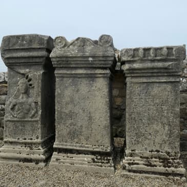
Emily:So our Mithraeum at Brocolitia has had the lower courses sort of reconstructed, and there were votive altars that were found there, and three of them have been set back up in replica form. The originals are actually in a museum in Newcastle, the Great North Museum.
Cam:Right, and these are great examples of the kinds of votive altars that you can find all over wall country, the sort of altar that was dedicated by somebody with money to spare who was seeking the favor of the god.
Emily:Now, one of the interesting things about the worship of Mithras is that in recent decades, it's experienced something of a resurgence as there's been movements to revive ancient pagan practices of worship. Mithras is one of the figures whom people have attempted to reconstruct practices for. And we had encountered before our first trip some articles talking about how Mithraism had had a resurgence, particularly among the British military. And of course, we were there in 2010 when the British army was still actively engaged in the war in Afghanistan. Of course, British troops were in active combat there. And this led to one of the more interesting experiences we had hiking the wall. As we got close to the Mithraeum, we saw a man go in in what looked like kind of military clothing. And he stopped at the entrance to the Mithraeum, paused for a moment. He took his hat off. He walked up to one of the altars. He put something in it. And then he stood there very quietly for a few seconds before he turned around and left. And what I'm pretty sure I saw is, we saw, is someone make an offering in prayer on the altar to Mithras and seeing the sort of revival of pagan practice in real life. It was quite moving to watch. I will note I wanted to take a picture and Cam would not let me. He said it was rude. We were at a distance he would never have noticed.
Cam:It still seemed weirdly invasive to me, yes. So we did end up taking a picture of what he had left on the altar afterwards.
Emily:So yes, we waited for him to finish and leave before we went in to explore the Mithraeum ourself. And yes, we found in this altar coins and flowers, a good number of them, as well as fluid. It looks like someone had poured a libation into the altar as well. I did get a picture of that. And I will say, when we did the wall the second time, we also found coins and flowers left on that same altar stone.
Cam:Yeah, it's a really interesting case in which this sacred site that was sacred to soldiers, what, almost 2,000 years ago, still has valence for people today and is still an active site of devotion.
Emily:Yeah, it was really cool to see that happen. It's not just something you read about or something you hear about, but to see someone do it in a way that was just personal. It wasn't about putting on a big show. It wasn't about anything other than his own experience and his own devotion. And it was a privilege, I think, to be able to see that.
Cam:Yeah, it was. And with that, I think we're probably a good stopping point for today.
Emily:Yeah. This is where we leave the route for today. Next episode, we'll pick up with the trail's journey along the crags on the south edge of Northumberland National Park, and we'll see how far we get in that episode.
Cam:Right. There's lots of trail left to come, so maybe this will only be one more episode. Maybe it will be two.
Emily:Probably going to be two.
Cam:I suspect it might be two, yes.
Emily:So I've been Emily.
Cam:I'm Cam.
Emily:And this has been Have Toga, Will Travel.
Cam:If you like this episode and you want to help support us, please do tell a friend about us. Passing along that sort of word- of-mouth recommendation is one of the best ways you can help the show grow.
Emily:And you can subscribe wherever you get your favorite podcasts. And you can follow us at have togawilltravel.com or on all the socials.
Cam:Thanks for listening, everybody. We'll be back in a couple of weeks.